MAPS OF TIBET
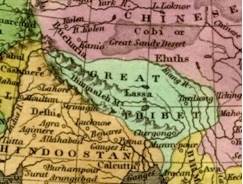
Detail from 1827 map [24]
Most pre-1950 maps, globes and atlases, including the earliest maps on record of Asia, depict Tibet as an independent nation, separate from China. Tibet is variously referred to as Tobbat, Thibbet or Barantola. A map of Asia drawn by the Dutch cartographer, Pietar van der Aa around 1680 shows Tibet in two parts but distinct from China; [25] as does a 1700 map drawn by the French cartographer Guillaume de L’isle, where Tibet is referred to as the “Kingdom of Grand Tibet.” [26] A map of India, China and Tibet published in the USA in 1877 represents Tibet as distinct from the two other nations. [27] An 1827 map of Asia drawn by Anthony Finley of Philadelphia, clearly shows “Great Thibet” as distinct from the Chinese Empire. [28]
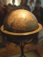
Martin Behaim’s globe at Nuremburg
The oldest existing globe in the world, and possibly the first terrestrial globe ever made, was constructed by Martin Behaim (geographer to the king of Portugal) in 1492. It depicts the world before the discovery of the Americas. Tibet is clearly identified in German as “Thebet ein konigreich”, or “ Tibet, a kingdom”. [29]
The largest stained glass globe in the world (in Boston), based on the Rand McNally 1934 map of the world, shows Tibet as a separate nation. [30]
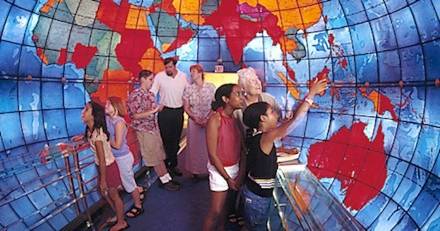
The “Mapparium” in Boston, MA.
Early Chinese maps do not feature Tibet as a part of China. In a landmark map of China [31] drawn in 1594 by Wang Fen (or Wang Pan?), a senior Ming Legal Officer, there is a note stating that the map included the whole of China ’s territory. But no Tibetan areas, not even the eastern-most regions of Amdo or Kham, appear on the map.
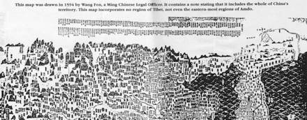
Upper section of 1594 Ming Map
Following the publication of the atlas commissioned by the Manchu Emperor Kangxi and created by French Jesuit cartographers, some Chinese and European maps begin to depict Tibet as a colony or protectorate of China. The Jesuits could not personally survey Tibet (as they had surveyed China and Manchuria), since Tibet was not part of the Chinese Empire. So they trained two Mongol monks [32] in Beijing and sent them to make a secret survey of Tibet. Similar clandestine surveys of Tibet were conducted by British mapmakers using trained Himalayan natives and even a Mongol monk. An American sinologist, writing on such issues, notes that, like European colonial powers, China used cartography to further its “Colonial Enterprise” in Tibet and Korea. [33]
TIBETAN CURRENCY
Literary sources [34] refer to gold, silver and copper ingot-coins, even cowrie shells, being used as currency in ancient Tibet. From circa 1650 silver coins for Tibet (the Bhal-tang) were struck in Nepal under a treaty agreement. [35] In 1792 following the defeat of Nepal by a joint Tibetan-Manchu force, coins bearing both Tibetan and Chinese inscriptions were circulated. But the Tibetan government continued to issue its own coin with only Tibetan legends as the Kongpar tangka (1791-93) and the Gaden tangka (1836-1911). A silver coin, the Kalsang tangka, was struck in 1909 possibly to mark the 13th Dalai Lama’s return to Lhasa from Peking.
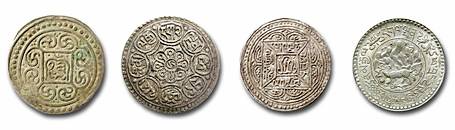
Kongpar tangka, Gaden tangka, Kalsang tangka and three Srang coin
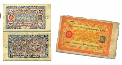
After the expulsion of the Chinese army in 1912, Tibet minted gold, silver and copper coins (in the “srang” currency unit) using Buddhist and Tibetan designs and bearing the name of the Tibetan government. Paper currency was introduced into Tibet in the early 20th century, and according to the numismatist Wolfgang Bertsch, these bank notes were “small works of art.” [36] A unique aspect of Tibetan banknotes was that the serial numbers were handwritten by a guild of specialist calligraphists, the
Even after the Communist invasion, Tibetans successfully resisted Chinese efforts to take over its currency. Official Chinese currency only came into use after the flight of the Dalai Lama and the Tibetan government from Tibet in March 1959. [37] In its entire history, official Chinese currency had never been used in Tibet before 1959.
TIBETAN PASSPORTS
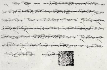
The Tibetan government issued its own passports to travelers entering its borders or (the few) Tibetans who traveled abroad. Before WWII, the term “passport” covered visas and travel documents in general. The earliest record of a Tibetan passport issued to a foreign traveler is in 1688 to an Armenian merchant, Hovannes (Johannes). [38] In 1780 a passport was issued from Lhasa [39] to Purangir Gossain, an emissary of the Governor-General of India, Warren Hastings, who hoped to open up Tibet to trade with the East India Company.
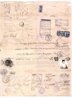
Passport issued to first Everest Expedition, 1921 (courtesy of Rinchen Dorjay).
The Tibetan government gave its approval for the first-ever Everest expedition in 1921. Charles Bell, the visiting British diplomat in Lhasa wrote “I received from the Tibetan Government a passport in official form, which granted permission for the climbing of Mount Everest.” [40] The subsequent Everest expeditions of 1924 and 1936 [41] also received passports from the Tibetan government. Passports were sometimes issued for scientific undertakings: the Schaeffer anthropological expedition of 1939, [42] Tucci’s ethnological expedition of 1949 [43] and the plant hunter Frank Kingdon Ward in 1924. [44]
Shakabpa passport
President Roosevelt’s two envoys to Tibet in 1942 were presented their passports at Yatung. [45] The Americans Lowell Thomas Jr. and Sr. visited Tibet in 1949, and were issued “Tibetan passports” at Dromo. “When the Dalai Lama’s passport was spread out before us, I could not help